In a Nutshell! Newsletter for May 2026
May 15, 2026
The In a Nutshell! newsletter brings you what's going on in and around Squirrel Hill.
The Squirrel Hill Urban Coalition’s Bicycle-Pedestrian Committee is developing a Bicycling Master Plan for Squirrel Hill. We see this as a broad overview and basis for discussion with the Squirrel Hill and bicycling communities.
Our focus is on routes in and through Squirrel Hill that form a useful transportation network. Routes in adjacent neighborhoods are included where our plans need to mesh with theirs. Mostly this means nearby routes we might connect to, but the routes along the Mon are important because they connect the SW and SE corners of Squirrel Hill and provide connection to the GAP. We recognize that there are other recreational mountain biking routes in Schenley and Frick Parks, but we omit those in the interest of simplicity. If someone wants to create a new layer for recreational mountain biking, we can add that.
Planners recognize four kinds of bicycle riders: “strong and fearless”, “enthused and confident”, “interested but concerned”, and “no way no how”. This plan identifies routes that will appeal to the enthused and confident and (especially) will attract the interested and concerned to bike more.
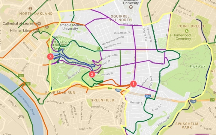
An interactive version of this map with further descriptions of various trails and plans is available here.
If you have comments about this plan, or would like to participate in the SHUC Bike-Ped committee, please email ped_bike@shuc.org.
The In a Nutshell! newsletter brings you what's going on in and around Squirrel Hill.
Enter your email address to subscribe to our newsletter and receive notifications of new posts by email.
this is a test
this is a test